- AU TAS UTAS ITCCD 2017/18-77
- Item
- 1920s
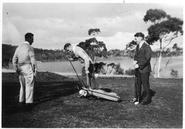
Three men playing golf, river in background.

1484 results with digital objects Show results with digital objects
Three men playing golf, river in background.
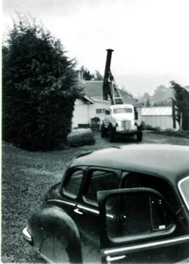
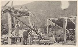
Truck-mounted crane hoists chimney into place
Black and white photograph. Small crane truck being used to position a chimney on the roof of a building.
Graeme Raphael
Part of Arthur Knight Slides
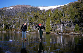
Colour photograph shows man and woman standing on frozen surface of Eagle Tarn, with snow-topped mountain ridge in distance
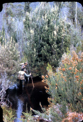
Two bushwalkers testing the waters
Part of Arthur Knight Slides
Colour photograph shows two men testing the creekbed in tea trea heathland
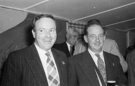
Two members of the Returned Service League
Two men at a function, both wearing RSL badges.
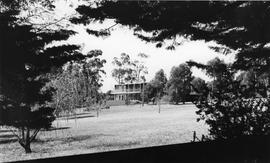
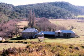
Two story house surrounded by trees and lawn
Photograph of a two story brick house with veranda, set on large area with trees and lawn.
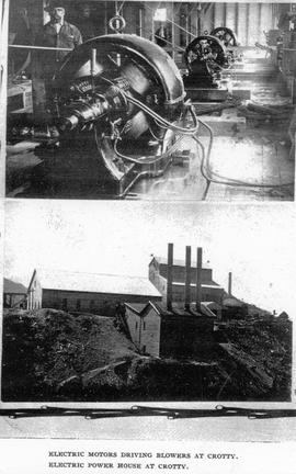
Two views of Crotty, Tasmania, showing electric machinery and power station.
Part of Images of West Coast Tasmania
Image likely sourced from a newspaper or publication as it contains printed legend at the bottom: electric motors driving blowers at Crotty (and of the lower image) Electric power house at Crotty.
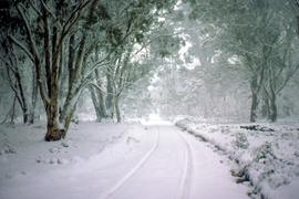
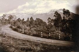
Tyre tracks in snow on Marlborough Highway
Colour photograph shows tyre tracks in heavy snow on Marlborough Highway, linking Lyell Highway and Lake Highway
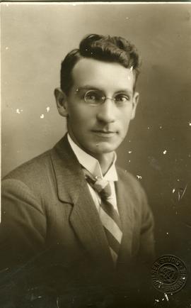
Photograph of gentleman wearing glasses, taken by Poulsen Studio, Brisbane.
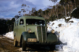
Vehicle on road at National Park
Part of Arthur Knight Slides
Colour photograph shows two-tone green vehicle with driver's fingers visible on steering wheel, on the unsealed road at National Park, with snow covering the higher ground. Tasmanian number plate reads WLA 189 - 19 TAS 56.
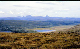
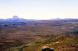
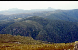
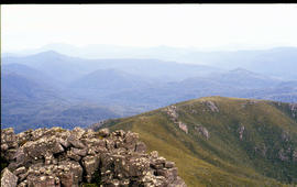
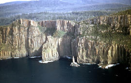
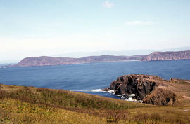
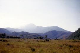
View across Cradle Mountain ridges to the north
Part of Arthur Knight Slides
Colour photograph shows people standing outside Northern Tasmanian Alpine Club hut at Ben Lomond, one holding snow skis and poles
Part of Arthur Knight Slides
Colour photograph shows shoreline of Lake Adelaide
Part of Arthur Knight Slides
Colour photograph shows Lake Lea in foreground, with Cradle Mountain and Barn Bluff in distance
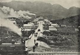
View across the railway line towards the town and mining works, Crotty, Tasmania
Part of Images of West Coast Tasmania
Image shows pedestrians in the main street, timber settlement and a stationary train in the foreground.
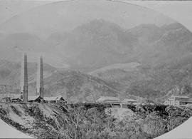
View across the smelters towards the hills at Crotty, Tasmania.
Part of Images of West Coast Tasmania
Image clearly shows the smelters in the foreground. Image is oval and slightly cropped.
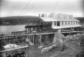
View downhill to River Derwent from E.Z. Co. Zinc Works 100-Ton Plant construction site
Black-and-white photograph shows view dowhill to River Derwent looking across construction site of E.Z. Co. Zinc Works construction site of 100-Ton Plant
Part of Arthur Knight Slides
Colour photograph shows people on western shore of Lake Timk 1974
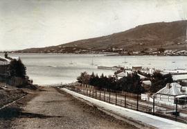
View from Bath Street, Battery Point
Part of Photographs of Edward Verrell
Black-and-white photograph of Bath Street, Battery Point, looking across Derwent River to Sandy Bay and St Helena Point.
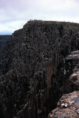
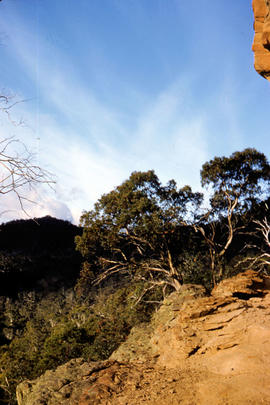
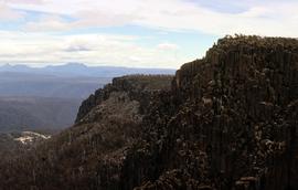
View from cliffs at Chauncy Vale
Part of Arthur Knight Slides
Colour photograph shows cliff and treetops at Chauncy Vale
Arthur Knight
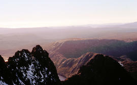
Colour photograph shows view from Devils Gullet Lookout
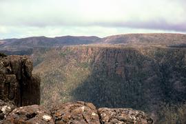
View from Devils Gullet lookout
Colour photograph shows view from Devils Gullet Lookout off Lake McKenzie Road
Part of Arthur Knight Slides
Colour photograph shows man in skis atop snow-covered roof of Dixons Kingdom hut
Part of Arthur Knight Slides
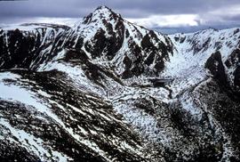
Colour photograph shows view of mountain range to the west of Mount Field West
View from Mount Field West across glacial valley
Part of Arthur Knight Slides
Colour photograph shows glacial valley from atop Mount Field West
View from Mount Murchison to Mount Heemskirk
Part of Arthur Knight Slides
Colour photograph shows snow skier at Piesse Vale on Ben Lomond plateau GIS Latitude -4154 Longitude 14763 Gazetteer Record_ID TAS13722 Source: https://wwwparkstasgovau/fileaspx?id=6392
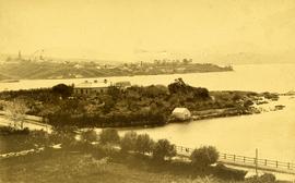
View from Queens Domain looking north to Cornelian Bay and New Town Bay
Part of Photographs of Edward Verrell
Black-and-white photograph taken from elevated point on Queen’s Domain, looking north up Derwent River towards Cornelian Bay and New Town Bay; Risdon Park Racecourse (1880s-1926) at New Town in foreground, early burial plots in headland of Cornelian Bay Cemetery at right of picture.
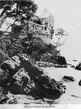
Part of Images of West Coast Tasmania
Image is likely sourced from a newspaper or publication as it is grainy and contains printed legend at the bottom: Old Court House, Sarah Island
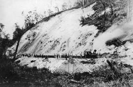
View of a railway cutting under construction, Queenstown Tasmania
Part of Images of West Coast Tasmania
Image has a steam engine and many mining carriages standing beside a steep hillside denuded of vegetation. Many men carrying shovels stand around, apparently working on the site. Image possibly connected to Mt Lyell mining operations.
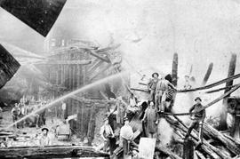
View of a substantial, multi storey ruined building destroyed by fire, Queenstown Tasmania
Part of Images of West Coast Tasmania
The image shows many men standing within the ruins facing the camera as a hose plays water onto the building. Electronic file is titled 'after fire.tif'
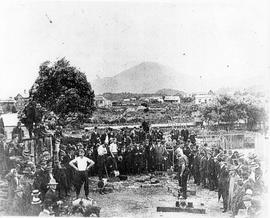
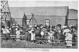
View of a wood chopping competition, Zeehan, Tasmania
Part of Images of West Coast Tasmania
Image shows a spectators around an area used for wood chopping.
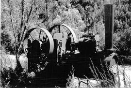
View of abandoned steam boiler in the bush at Crotty, Tasmania
Part of Images of West Coast Tasmania
Image is a close up of the ruined boiler showing funnel, wheels and other parts.
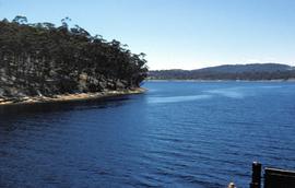
Part of Hal Wyatt Collection
Colour photograph taken 1960 of Barnes Bay, Bruny Island, slightly out of focus, showing water and tree-covered headland
Hal Wyatt
Part of Arthur Knight Slides
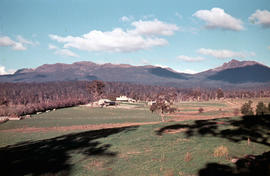
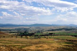
Colour photograph shows open farmland in the foothills of Ben Lomond
Part of Images of West Coast Tasmania
Image is likely sourced from a newspaper or publication as it shows legend at the bottom identifying the scene and photographer.
Colin Dennison
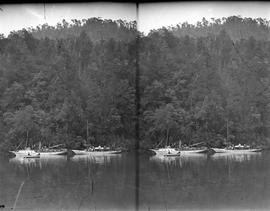
View of boats on the Franklin River, Macquarie Harbour, Tasmania
Part of Images of West Coast Tasmania
Image possibly taken from original glass plate. Shows two vessals on the river with hills behind and occupied row boat in the foreground. Image appears twice, side by side with narrow shadow down the centre. When compared with image Boats on the Gordon.tif it is possible the view is of the Gordon River.
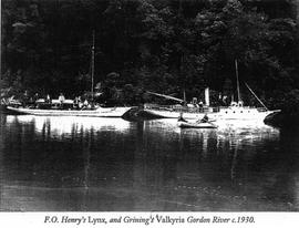
View of boats on the Gordon River, Macquarie Harbour, Tasmania
Part of Images of West Coast Tasmania
Image like sourced from a newspaper or publication as quality is grainy and contains legend at the bottom: F.O. Henry's Lynx and Grining's Valkyria, Gordon River, c1930. Compare with Boats on Franklin.tif
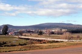
View of Bothwell in winter, 1981
Colour landscape photograph showing township of Bothwell, looking east across the willows on the banks of the River Clyde, taken in winter 1981.
View of Bowers Hotel, Queenstown, Tasmania
Part of Images of West Coast Tasmania
Black and white probably non professional image of the hotel showing the corner view.
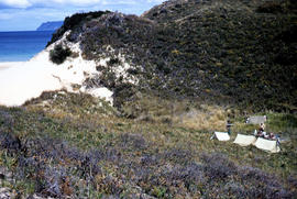
View of Bruny Island campsite of Hobart Walking Club 1955
Part of Arthur Knight Slides
Colour photograph of heath and sand dunes, site of Hobart Walking Club campsite near Cape Queen Elizabeth on Bruny Island,1955
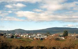
View of Burnie hinterland looking west from Round Hill
Part of Hal Wyatt Collection
Colour photograph of Burnie hinterland, mouth of Emu River at Emu Bay and smoke billowing from the APPM pulp and paper mill at South Burnie, taken from top of Round Hill. looking west-south-west/
Hal Wyatt
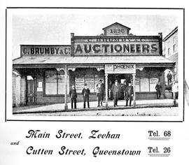
View of C Brumby & Co, Auctioneers, Queenstown, Tasmania
Part of Images of West Coast Tasmania
Image shows various men, possibly staff, standing on the verhanda. Lower half of the image shows the addresses of the offices in Zeehan and Queenstown. Image likely to have been an advertisement.
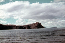
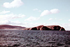
View of Cape Bruny and lighthouse from Lighthouse Bay
Part of Arthur Knight Slides
Colour photograph of waves breaking in Lighthouse Bay, with cliffs and headland of Cape Bruny and Bruny Island Lighthouse in background. Discolouration in scanned image from original slide.
View of Cape Bruny and lighthouse from Lighthouse Bay
Part of Arthur Knight Slides
Colour photograph of cliffs of Cape Connella, South Bruny Island
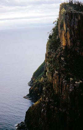
View of Cape Connella from sea level
Part of Arthur Knight Slides
Colour photograph shows Cape Connella taken at sea level
View of Cape Connella from sea level
Part of Arthur Knight Slides
Colour photograph of Cape Connella, viewed from sea level several hundred metres offshore
View of Cape Connella from the air
Part of Arthur Knight Slides
Colour aerial photograph of cliffs of Cape Connella, viewed from the air.
Part of Arthur Knight Slides
Colour photograph, taken at sea, looking towards Cape Queen Elizabeth, Bruny Island
Colour landscape photograph of property Cawood, Ouse,
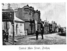
View of Central Main street, Zeehan, Tasmania
Part of Images of West Coast Tasmania
Image has printed label at the bottom and is possibly a post card.
Part of Arthur Knight Slides
Colour photograph shows treeline and valley at Chauncy Vale
Arthur Knight
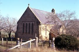
View of church yard surrounding St James chapel at Montacute
Colour photograph taken in winter, shows burial ground and churchyard surrounding St James Chapel at Montacute, under the care of the Hallett Family, since 1897
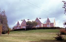
View of Clifton Priory and powerlines across front lawn
Colour photograph of Clifton Priory, Bothwell, showing powerlines across front lawn below hedge. National heritage register citation is as follows: “Two storey stone Tudor Gothic house built in 1847-8 by Rev. Robert Wilson from public subscription. Wilson caused a scandal when he ran into financial difficulties and sold it owing a considerable sum. The house is magnificently sited on Barrack Hill from where it enjoys fine views of Bothwell, the Clyde River and surrounding countryside.”
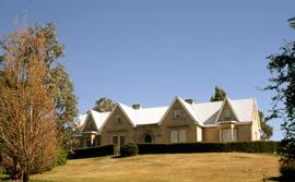
View of Clifton Priory atop Barrack Hill, Bothwell
Colour photograph of Clifton Priory, Bothwell, showing gardens, lawn and hedge below front door. National heritage register citation is as follows: “Two storey stone Tudor Gothic house built in 1847-8 by Rev. Robert Wilson from public subscription. Wilson caused a scandal when he ran into financial difficulties and sold it owing a considerable sum. The house is magnificently sited on Barrack Hill from where it enjoys fine views of Bothwell, the Clyde River and surrounding countryside.”
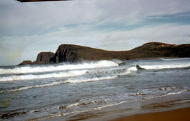
View of Cloudy Bay and West Cloudy Bay
Part of Arthur Knight Slides
Colour photograph of Cloudy Bay and West Cloudy Bay, Bruny Island.
View of Cloudy Bay from East Cloudy Head
Part of Arthur Knight Slides
Colour photograph of Cloudy Bay from East Cloudy Head
View of Clyde River Bridge, Bothwell, Tasmania
Colour photograph of timber bridge across Clyde River, Bothwell, Tasmania
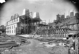
View of construction site uphill at E.Z. Co. Zinc Works at Risdon 1924
Black-and-white photograph shows view of new building on site, looking uphill, at E.Z. Co. Zinc Works at Risdon 1924
Part of Photographs of Edward Verrell
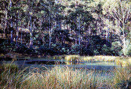
Black-and-white photograph looking south at Cornelian Bay on the Derwent River, with one boatshed on far shore
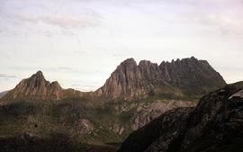
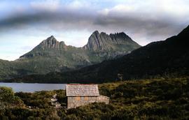
Colour photograph of Cradle Mountain, taken from track near Marion’s Lookout
View of Cradle Mountain and Barn Bluff
Colour photograph of view towards Cradle Mountain and Barn Bluff, showing scree and boulders on mountain tops near Devils Gullet and Fisher Power Station in foreground
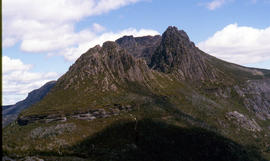
View of Cradle Mountain ridgeline from Hansons Peak
Part of Arthur Knight Slides
Colour photograph of Cradle Mountain from Hansons Peak
View of Cradle Mountain, Dove Lake and boatshed
Colour photograph shows Cradle Mountain, Dove Lake and boatshed,
View of Crater Lake, near Cradle Mountain
Colour photograph shows Crater Lake, near Cradle Mountain
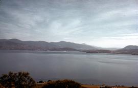
View of Derwent River from Doughty Point 1952
Part of Hal Wyatt Collection
Colour photograph of Derwent River, viewed from Doughty Point, taken 1952.
Hal Wyatt
View of Dove Lake and Honeymoon Island
Colour photograph shows Honeymoon Island in Dove Lake, near Cradle Mountain
View of Dunkleys Point at Sandy Bay
Part of Photographs of Edward Verrell
Black-and-white photograph shows Sandy Bay Road in foreground, the grand home St Helena on what is known as Dunkleys Point, and Battery Point on the opposite shore of the bay
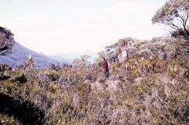
View of heathland near Mount Bowes
Part of Arthur Knight Slides
Colour photograph shows heathland looking southwest from near Mount Bowes
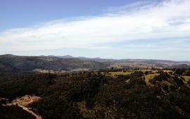
View of hills around Crotty 1970
Part of Hal Wyatt Collection
Colour photograph shows track cut into foothills at Crotty, 1970.
Hal Wyatt
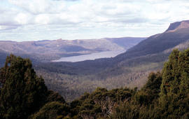
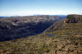
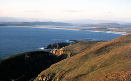
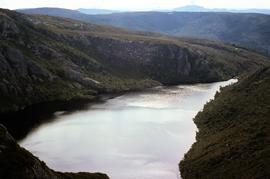
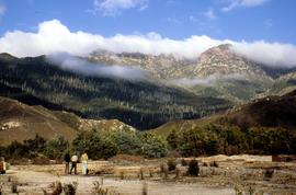
View of Lake St Clair from Mount Manfred
Part of Arthur Knight Slides
Colour photograph shows motor boat on Lake Trevallyn
Arthur Knight
View of lighthouse at Cape Bruny
Part of Arthur Knight Slides
Colour photograph of Bruny Island lighthouse looking south
View of Little Horn of Cradle Mountain and Dove Lake
Colour photograph of Little Horn and Dove Lake, Cradle Mountain
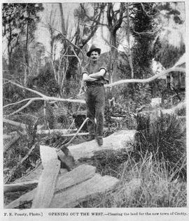
View of male axeman standing on fallen timber in the bush, Crotty, Tasmania.
Part of Images of West Coast Tasmania
Image likely sourced from a newspaper or publication as it contains printed legend at the bottom: Opening out of the west - clearing the land for the new town of Crotty. Photographer identified. Primitive buildings just visible in the background. It is likely the image is older than 1902.
F.E. Pousty
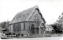
View of Methodist church in Carpenter Gothic Style, Zeehan, Tasmania
Part of Images of West Coast Tasmania
Image has "Zeehan" in hand writing in the lower left corner.
View of mine works at Comstock, near Zeehan, Tasmania
Part of Images of West Coast Tasmania
Image shows men standing beside winches, rail carts and other aspects of the mining operations.
Colin Dennison
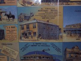
View of Montagu Hotel, Bowes street Queenstown Tasmania
Part of Images of West Coast Tasmania
Image is only one of a number of businesses on a colour advertising sheet. Others shown include Royal Hotel and JB Wood, hairdresser.
View of motor car on sandy track with old sign "Crotty", Crotty, Tasmania
Part of Images of West Coast Tasmania
View of motor vehicles outside the Queenstown Hotel, Queenstown, Tasmania
Part of Images of West Coast Tasmania
Image centres on the two motor vehicles and adjacent figures, showing the ground and part of the first storey of the Queenstown Hotel. Affixed to first-storey railing is a large banner promoting Newtown v Queenstown football match on Saturday August 6th.
View of Mount Field West from Florentine Peak
Part of Hal Wyatt Collection
Colour photograph of Mount Field West from Florentine Peak 1966
View of Mount Huxley near Crotty
Part of Hal Wyatt Collection
Colour photograph of Mount Huxley and Crotty at sunset, 1970.
Hal Wyatt
View of Mount Jukes from site of former Crotty smelters
Part of Hal Wyatt Collection
Colour photograph shows three people standing on a former industrial site at Crotty, in front of Mount Jukes, a rocky mountaintop with heavily timbered foothills.
Hal Wyatt
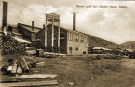
View of Mount Lyell Co's Electric Power Station, Queenstown Tasmania
Part of Images of West Coast Tasmania
Image is slightly out of focus and contains text identifying the subject. Possibly originally a post card.
View of Mount Mawson from Florentine Peak saddle
Part of Arthur Knight Slides
Colour photograph shows Mount Mawson viewed from saddle of Florentine Peak, with partial snow cover
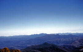
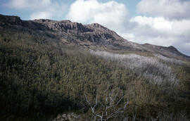
View of mountain ranges west of Mt. Lord
Part of Arthur Knight Slides
Colour photograph of mountain ranges west of Mt. Lord
View of Queenstown Central School, Queenstown Tasmania
Part of Images of West Coast Tasmania
Image is copy of from a series of large format negatives created by the Teaching Aids Centre, Brisbane Street, Hobart, 1951 - 1973 and held at Tasmanian Archive and Heritage Office: AB713-1-5635
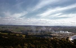
Part of Images of West Coast Tasmania
Image is taken from an adjacent hill and has the hotel in the centre of the picture. Image is in colour and shows extensive environmental degradation of the landscape.
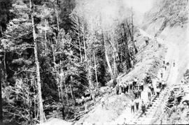
View of railway line under construction, Queenstown Tasmania
Part of Images of West Coast Tasmania
Image has a steam engine and many mining carriages standing beside a steep hillside denuded of vegetation. Many men carrying shovels stand around, apparently working on the site. Image possibly connected to Mt Lyell mining operations.

Part of Hal Wyatt Collection
Colour aerial photograph of snow-topped ridge of Reeds Peak
Part of Arthur Knight Slides
Colour photograph shows Russell Falls as viewed from elevated vantage point in rainforest
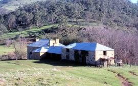
Colour photograph of sandstone homestead, Sherwood, with farm outbuildings and Clyde River Valley
View of Sherwood, homestead in Clyde River Valley
Colour photograph of sandstone homestead, Sherwood, with nearby outbuildings, willows lining the banks of nearby Clyde River at Hollow Tree
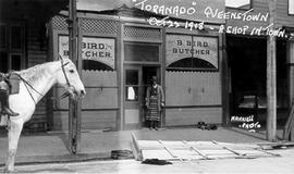
View of shop, B Bird Butcher with proprietor outside, Queenstown Tasmania
Part of Images of West Coast Tasmania
Image shows street scene with partial images of adjacent shops. B Bird Butcher's shop depicted, with man in apron standing in doorway, dog on footpath nearby, plus horse under saddle standing in road. Contains contemporaneous hand written text 'Toranado' (sic) Queenstown Oct 22 1918 - A shop in town. The Photographer's name is also on the image, in the same script 'Nankivell'. Toranado may refer to a storm experienced by the town in October 1918 and described as a tornado.
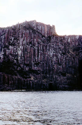
View of shoreline at base of Cape Connella, looking down cliff face
Part of Arthur Knight Slides
Colour photograph of shoreline at base of Cape Connella, South Bruny Island, looking down the cliff face.
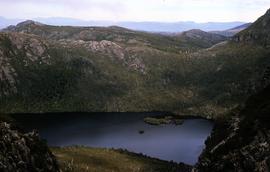
View of shoreline of Lake St Clair looking to Mount Olympus
Colour photograph shows people on beach of shoreline at Lake St Clair, with cloud cover above Mount OIympus in distance
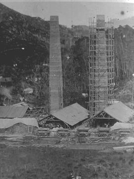
View of smelters at Crotty, Tasmania.
Part of Images of West Coast Tasmania
Image shows one chimney stack under scaffolding and other buildings under construction.
View of smelters showing construction works and slag disposal at Crotty, Tasmania.
Part of Images of West Coast Tasmania
Image shows close up of the smelters. A vertical shadow crossing the image is visible in the left third of the image.
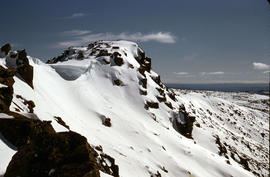
View of snow on ground at Reeds Peak and nearby lakes
Part of Hal Wyatt Collection
Colour aerial photograph of Reeds Peak with lakes in foothills
View of snow on Mount Wellington from Huon Road
Part of Photographs of Edward Verrell
Black-and-white photograph shows snow on Mount Wellington viewed from the verge of the Huon Road, South Hobart, with post-and-rail fence alongside roadway.
Colour landscape photograph of heavily forested area at Staverton and Cethana, in the Kentish Municipality, near Sheffield, Tasmania.
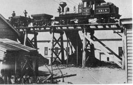
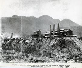
View of steam train on trestle bridge likely at the smelting works, Crotty, Tasmania.
Part of Images of West Coast Tasmania
Image likely sourced from a newspaper or publication as it contains printed legend with hand written amendment at the bottom: Smelter site showing works in course of construction and method of disposing of slag. Mount Jukes in the background. Crotty 1898.
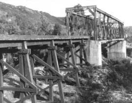
View of steel railway bridge with adjacent timber trestle extension, Crotty, Tasmania
Part of Images of West Coast Tasmania
Image shows the bridge in good condition making the dating difficult. Image quality tends to suggest a later date.